From Sandbags to Datasets: New AI-powered Flood Readiness Model Helps identify 1.2m Undefended Buildings at Risk of Flooding in England

Snowflake and Ordnance Survey collaborate on landmark AI-powered Flood Readiness Model data project
Unprotected buildings include many in areas of high social deprivation, period buildings and those at risk of hard to defend surface water flooding
Model combines high-resolution building data with flood data, social deprivation data and 3,000 pages of flood planning
April 15, 2026: Approximately one million buildings in England, many in the country's most deprived areas, could be outside existing flood protection and planning, a new cutting-edge, AI-powered data model suggests.
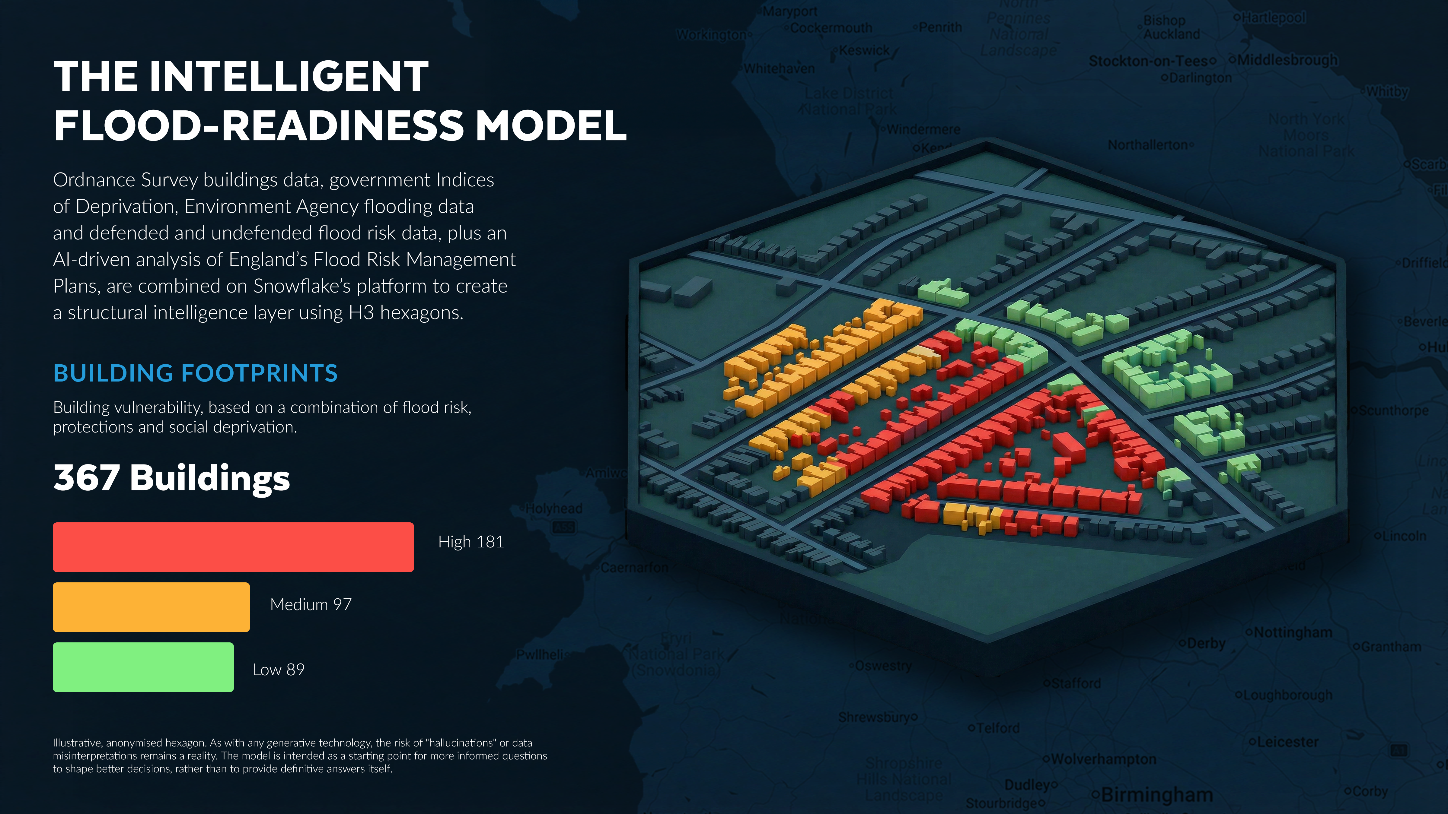
These are the findings from the Intelligent Flood Readiness Model, created by Snowflake, the AI Data Cloud company, built on Ordnance Survey (OS) data. The model combines OS's highly-detailed and frequently-updated buildings data with a range of government data and current Flood Risk Management Plans (FRMPs). Based on model analysis of available datasets, the output suggests that as many as 1.2 million buildings in England are at risk of flooding, but fall outside any current flood defences.
By layering mapping, flood risk and social deprivation data, the model estimates that up to 68% of these buildings could be highly vulnerable to the after-effects of flooding – at elevated flood risk, but also located in deprived areas and potentially lacking the resources and social infrastructure to help recover quickly. A contributory factor is likely to be that as much as 84% of these undefended buildings pre-date 2001 - before legislation ensured flood risk was factored into planning permissions.
Additionally, the model suggests that 15% of the at-risk premises date from before 1919, and 23% from 1919 to 1959, so were potentially built before their location became a flood risk - underlining just how dynamic England's natural and built environment is, as captured by OS's geospatial data.
So many undefended buildings being built before 1960 also means they may need specific plans for their protection and recovery. And with the model also pointing to the complexity of England's neighbourhoods - mixing high-rise, new-build flats with Victorian detached houses - the complexity of the challenge facing flood planners is clear, as is the need for accurate, granular data.
The model combines six entirely separate, critical data streams and synthesises them into a single, shared "structural intelligence" layer. By cross-referencing OS's authoritative building datasets with the Indices of Deprivation in England, the analysis was able to identify where physical vulnerability (building height and type) intersects with social risk. This was then layered against Environment Agency (EA) flood data, the EA's Rivers and Sea defended and undefended flood risk extents, and an AI-driven text analysis of over 3,000 pages of statutory FRMP documents.
The resulting model will help policymakers better understand, over relatively small, detailed areas, not just the likelihood of flooding, but how vulnerable neighbourhoods may be to its effects. Rather than give definitive answers, it is intended to help guide them to ask better questions that are built on data-driven insights, to stress-test plans before flooding happens and identify areas to investigate further.
Scenarios to explore further highlighted by the model include:
Areas around the east coast of Yorkshire and the Humber have the highest estimated concentration of undefended, vulnerable properties
The burden of flood recovery appears likeliest to be borne by individual households, with around two thirds (64%) of buildings affected classed as residential
Of the remaining buildings, around 15% are commercial, 10% industrial and approximately 5% infrastructure, crucial to local areas' post-flood recovery, but often beyond the measures outlined in FRMPs
Protecting every at-risk home would almost certainly not be feasible using current methods - vulnerable buildings look to be scattered around the country, with nearly two-fifths of neighbourhoods\* (37%) containing at least one such property.
The model also acts as a corrective to some of the popular perceptions of flood risk. It suggests that 85% of at-risk, undefended buildings are vulnerable to surface water flooding, rather than river or coastal flooding. Consequently, high-density, multi-unit residential buildings may account for more at-risk households than those in more obviously threatened seafront or riverside locations.
Fawad Qureshi, Global Field CTO, Snowflake said: "Data is at the heart of making informed decisions. As this project shows, it's rare that one body holds all the relevant data or that this data is in the same format. But we're now in an era where technology can bring together the right people and the right data to collaborate on making better informed decisions."
Tim Chilton, Managing Geospatial Consultant, Ordnance Survey added; "Ordnance Survey is excited to collaborate with Snowflake to develop an innovative AI model that could help Local Authorities better understand, plan for, and manage floods. Built on OS's authoritative and trusted geospatial data and developed using Snowflake's technology, the model provides insights into how well areas and properties are protected and where to prioritise investment in critical flood defences. By delivering geospatial intelligence difficult to derive manually, decision-makers can access data-driven, actionable insights - without the burden of analysing endless spreadsheets. The model maps vulnerable zones and identifies areas at greatest risk, helping local government shape policy, direct resources, and safeguard communities."
One of the many challenges facing those drawing up flood plans is that the natural and built environment, and the data tracking this, can move more quickly than policymakers can keep up with. FRMPs are only produced every six years for broad geographical areas, and are currently informed by relatively high-level data. Yet the make-up of that area, and how flood water may impact properties, can vary widely - and change frequently.
AI-powered tools, bringing together multiple sources of rich, regularly-updated data, can help bridge this gap, shifting from static plans to dynamic models and raising the possibility of digital twins to examine how buildings could be affected before flooding happens.
And by identifying properties that are potentially newly-vulnerable, as geographic data is updated, they can help produce more tailored, cost-effective flood plans, at the local authority or ward level, or even street-by-street.
The model has five key recommendations for policymakers to investigate in order to better address the risks that England faces from more frequent flooding:
1. Use the ability of models like these to analyse more granular data to move from treating wide, geographic areas as homogenous to factoring in neighbourhood or individual building vulnerabilities. This wouldn't mean thousands of unique plans; policymakers could identify plans for period properties with basements, for example, and apply that protocol to areas where these properties are shown to exist.
2. Understand where there are clusters of vulnerability, especially when these areas straddle arbitrary boundaries like local authorities or FRMP zones.
3. Look at surface water infrastructure investment - with most properties at risk from surface water flooding, investment in unseen infrastructure, like better drainage, could pay dividends.
4. Consider a vertical risk assessment, factoring the height of a building as well as their footprint and creating specific high-rise emergency protocols.
5. Factor in social deprivation to plans, as this will influence how well an area can deal with and recover from the aftermath of flooding. Two areas could have very similar natural geography and buildings but very different levels of deprivation or wealth.
Qureshi concluded: "Rather than relying on hindsight, static maps and fragmented datasets, we can turn the latest, highly granular data into a structural intelligence layer, and use AI to interrogate how effective current plans are likely to be. It's not the final answer, but it can inform the next question, and help offer more protection to some of our most vulnerable neighbourhoods before the first drop of rain falls. This is a clear example of how organisations can combine real-time data, scalable compute, and advanced AI to simulate scenarios, stress-test plans, and continuously refine strategy, helping identify recommendations to protect communities with precision and confidence."
NOTES TO EDITORS
* Technically 37% of Lower Layer Super Output Areas (LSOAs). These are small, consistent geographic units in England and Wales designed by the Office for National Statistics for reporting census and small-area data. They typically contain 400–1,200 households and 1,000–3,000 residents.
Estimates are based on modeled analysis of multiple datasets and assumptions and should be interpreted as directional insights rather than precise counts. Further, as with any generative technology, the risk of "hallucinations" or data misinterpretations remains a reality. While this AI-driven approach provides a powerful roadmap for identifying previously hidden patterns, the project partners emphasise that these findings are intended to augment, rather than replace, human expertise - identifying areas where plans may not meet local needs and where further investigation is needed.
About Ordnance Survey
Ordnance Survey (OS) is Great Britain’s National Mapping Service, providing the trusted location data that underpins everyday life. From transport and utilities to housing and logistics, our data supports critical infrastructure, public services, and economic growth.
We maintain the National Map, a vast database of over 600 million geospatial features, updated 30,000 times a day. Our expertise in location intelligence helps businesses, government, and communities make smarter decisions - whether planning sustainable cities, managing climate risks, or improving connectivity - because everything happens somewhere.
As part of the Department for Science, Innovation and Technology (DSIT), we are driving the future of geospatial insights, ensuring Britain remains a leader in location data, and enabling a better-connected, more efficient and resilient nation.
About Snowflake
Snowflake is the platform for the AI era, making it easy for enterprises to innovate faster and get more value from data. More than 13,300 customers around the globe, including hundreds of the world’s largest companies, use Snowflake’s AI Data Cloud to build, use and share data, applications and AI. With Snowflake, data and AI are transformative for everyone. Learn more at snowflake.com (NYSE: SNOW).
